Thursday, July 7, 2022

Mesa Verde National Park, Colorado

Having just recently returned from a trip to the Southwest, I was very pleased to review my photos and remember with fondness all that happened on the trip. On my way to Mesa Verde I camped at Navaho National Monument, situated within the Navaho Nation.  A pleasant surprise, with lots of hikes and ruins to observe. 
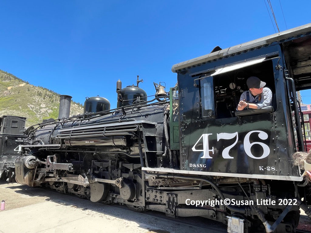
After reaching Cortez, Colorado, I met up with my friend Cindy to camp and visit the area. After setting up camp we rested as we had an early start the next morning. The following day, we drove to Durango, Colorado, and took the Durango and Silverton Narrow Gauge Railroad for a journey through some awesome scenery up to the old mining town of Silverton. 
The train is an old fashioned steam engine train that has been in continuous operation since 1882! It was originally constructed to haul silver and gold ore from the San Juan Mountains.
That would be my friend Cindy and me riding the rails on the old steam train.
This plant resembles a giant dandelion, but is actually called Western Salsify. Even though it is edible it is very bitter. I'd rather have chocolate.
View from the train along the Animas River, one of the last free flowing rivers in the entire western United States! That night we pulled into our campground so tired from the long day. Our tour in the morning started at 8:30 am, so before crashing in bed, we hastily made our preparations for the following day of hiking in Mesa Verde National Park, 
The first ruins we visited, Long House, required you to visit with an NPS Ranger. I would suggest making a reservation on recreation.gov if  you plan on visiting Mesa Verde. With tickets in hand, we met up with the others and sadly watched some turned away because the quota was filled. Long House is located on the Weatherhill Mesa, and has 150 rooms, 21 kivas and a row of upper storage rooms. Amazing place. Highly recommend going there. The ruins were excavated and stabilized between 1958 and 1963, which enables people like me to go and see them!
From the ruins, the Ancestral Pueblo people had a tremendous view of the valley below.
The Ancestral Puebloan people built their villages under overhanging cliffs. They basically used sandsotone shaped into rectangular blocks,  and for mortar they used a mix of dirt and water. 
After we left LongHouse, we walked down to the Nordenskiold Site #16 ruins. By then we were pretty tired, and headed back to camp to prepare for the following day.
Beautiful cactus flowers, which after they transform into fruit, can also be eaten.
The following day we drove over to Square Tower House, and took a fabulous hike with 2 rangersI The whole hike was challenging, but coming down that steep ladder and then grabbing onto another ladder to finish the traverse, was extremely challenging.  That is Cindy taking her time coming down the ladder. It scared me to watch her, so I immediately turned my head until she reached solid ground. 
Everyone made it safely down and back up the ladders......no hikers were injured on the treacherous climb to the Square Tower.  ðŸ˜Ž
That would be me, gazing at the ruins, and probably dying of hunger pains.  Seriously I did not get enough to eat on that whole trip. Poor baby girl.
Looking through any window always intrigues me, especially this one. What was it like for these people to live in these impossible places? I don't know how they did it, I just know I couldn't do it. I encourage you all to keep your eyes out for my future blog posts of Capitol Reef, Bryce, Arches, Zion, Natural Bridges and no, I did not go to Canyonlands! Been there once and that was enough for me. Blessings to all of you and stay safe!

Monday, February 7, 2022

Joshua Tree National Park, California


Yes, that would be me! I have finally gone gray, or white or silver...whatever.  No, that would not be my teardrop trailer. My friend Cindy Keirsey came down from Washington in her brand new tear drop trailer to go camping with me in Joshua Tree National Park! Way to go, Cindy!
This National Park Service link for Joshua Tree National Park, will give you all the info you need to enjoy your stay in this land unlike any other. Very little vegetation, mostly scrub, Joshua trees, a few piñon pine, some desert trees and yuccas. But its the rocks that are to die for!
The blue sky and white clouds enhance the beauty of the dry landscape. If you do plan on visiting Joshua Tree, try to get a campground reservation at recreation.gov as it has gotten so crowded in recent years. There are several first come, first served campgrounds that do not require reservations, but they get taken very quickly. It's also a good idea to arrive early at the entrance Kiosk, as there can be a long line of cars waiting to get in.
Even people like me who are not experienced rock climbers, go there to climb all over the boulders and enjoy the scenery. My friend Cindy loved it, although she didn't love the 34 degree temperature at night and the cold wind that blew with it.
This isn't exactly the season for flowers in the desert, but we did find this one yucca bloom that looked so pretty. In the spring, lots of wildflowers, cactus flowers and the Joshua Trees all bloom.  Makes it quite the place to be!
Cindy on the left, me on the right, out hiking in Hidden Valley. Ive known Cindy since the 80's and have enjoyed our friendship over the years. Together we've hiked at Mt Rainier National Park, Olympic National Park and now Joshua Tree National Park!
Growing up, I didn't really like the desert until 2005 when I started camping in the southwest. So many wonderful places to see like Arches National Park, Zion National Park, Capitol Reef National Park, Grand Canyon National Park and Joshua Tree National Park. Camping and hiking in these beautiful places in the southwest has opened my eyes to a whole new world.
One big fat boulder, perched on several other big fat boulders. Wouldn't you have loved to watch that baby fall into place?
Skull Rock, a nice place to hike to. A bit strange, but fun.
On our second night in Joshua Tree National Park, just as the sun was starting to set, we climbed up the rocks behind our campsite in Jumbo Rocks, and looked down on our campsite. 
The sunset was spectacular. From our campsite, you could look down from the rocks and watch the sky turn glorious shades of orange, red and yellow. The amphitheater is the structure you can see in the distance.
Every sunset lasts such a short time, so if you don't move quickly you will miss out on God's magnificent handiwork! So amazing.
One lone camper up on the rocks doing the same thing we were doing. 

My faithful little orange tent, nestled in the boulders to keep some of the wind out. However I will not lie; I froze my little behind off all through the night. I had on every stitch of clothing, my down sleeping bag, an inflatable ground cover, a hat, gloves, and two extra blankets over me. How I wished for my warm fuzzy slippers my sister Judy had given me. But unfortunately they were at home and I was at Joshua Tree freezing my butt off. Cindy offered to share the warmth of her tear drop trailer but I insisted on toughing it out in the cold. Good night to one and all. May your nights be warmer, and your days filled with joy and adventure. Susan Little.....the camping queen.

Saturday, August 21, 2021

Bodie State Historic Park, Bridgeport, CA


After my visit in Yosemite, CA last month,  From there, I drove back over the Monitor pass to Bodie, located in Bridgeport, CA. It was a beautiful drive and fortunately I was able to see it all before the fires hit. My deepest sympathy goes out to all those affected by the recent fires in northern CA. 
It was late in June when I passed by a herd of sheep grazing on the green hillside.
I love birds, and was happy to see this violet green swallow nesting in the side of this building.This colorful  bird kept bringing food to her little ones tucked safely away inside.
The closer I got to Bodie, the wide open spaces captured me with their beauty. 
At last I arrived and jumped right in to exploring the old ghost town. In 1859 gold was discovered in Bodie, by W.S. Bodey after whom the town is named. At one time Bodie's mines produced gold valued at more than $100 million!
Old machinery holds such a fascination for me. I don't even know what it was used for, I just love the shapes, lines and color.  
I also love windows, and this side of the building had windows upon windows!
Colorful old machinery and lanterns tmade me want to get out my paints and create.

 Peeking through the windows of one building led to this scene.
I walked in the heat, sweating profusely, as I took pictures of the wagons and old barns.

This picture above is a safe, for storing money and valuables. I found it when I peeked through the door of the crumbling brick building below. James S. Cain was a pioneer banker and miner who moved to Bodie and set up shop in this building.  At one time he owned the only bank in Mono County.

Some of the buildings have been reinforced, in order to keep them from falling over. Not everyone is happy about the changes made to Bodie, but if they weren't made, nothing would remain standing.
After I left Bodie, I drove down Highway 395 to Obsidian Dome, an otherworldly place I had never seen. The dome was created by an explosion that took place when magma reached the water table, turned the water to steam, and pushed the magma up to cool and form rock.
The USDA has a website for Obsidian Dome,  and there is also a campground nearby. An amazing place that is just mind boggling.
After camping overnight near Obsidian Dome,  I continued down Highway 395 and stopped at Fossil Falls. A short trail takes you down to the falls. This is not your usual waterfall, but is actually the polished remnants of a 20,000 year old lava flow. In the back of the picture, you can see a spot of red, which belongs to a man hiking with two young boys. It gives you a little bit of an idea how huge the place is. By then, the temperature was over 100 degrees and it was all I could do  to just get back to my car without fainting from heat exhaustion! With Fossil Falls being my last stop, I finished the drive home and ended my month long Sierra trip. 

Friday, July 30, 2021

Yosemite National Park, California

Several weeks ago I took a month long camping trip through the Sierra Nevada Mountains. My highpoint was Yosemite National Park, where I spent over a week basking in the beauty. My campground was just outside the park and was situated right on this creek and waterfall!
The campground I stayed in was surrounded by these mountains, creek and meadows.
Down at the creek near my campsite, kids would gather on the log and keep cool. It was fun to talk with them but oh how I wished I could go out there with them. Knowing I would undoubtedly fall in, I stayed on the shore, and just dunked in the water when I got too hot.
To enter the Park I had to reserve two, 3-day passes that I purchased online. Believe me....they will not let you in if you do not have a reservation. To learn more, click on the NPS website for Yosemite reservations. On the first day of my pass, I drove through the entrance gate of Yosemite National Park and  drove straight to Tuolumne Meadows. The sun was just rising and cast a  pink glow upon the quiet water. As a kid, my aunt took me and my siblings camping in Tuolumne Meadows nearly every summer. It left a deep impression upon my soul, one that continually brings me back to nature for healing and restoration. I am forever grateful to my aunt for introducing me to the unparalleled beauty and peace in this place.
As soon as I sat down by the water, a mother duck with her ducklings came waddling by. So sweet!
I stopped at Lembert Dome, one of my favorite places in Yosemite. Lembert Dome is a granite rock formation that rises 800 feet above Tuolumne Meadows. I didn't climb to the top this time, but in the past, I joined several different ranger led hikes that brought me to the top of Lembert Dome!
 I not only visited my old favorites places but found new ones, to enjoy! The water is so clear you can see straight to the bottom, but it sure is cold......freezing cold.
I have always wanted to hike the John Muir trail from Mt Whitney to Yosemite, 213 miles of intense beauty and rugged terrain. I have come to grips with the fact that I will never hike the JMT, or the PCT or the AT, but I have been on all three for a small portion of the journey.  I really admire those folks who have hiked the complete trails!
There are so many different hikes you can take in Yosemite National Park. In the Tuolumne River area, I took this short hike to the Lyell Fork of the Tuolumne River. 
Streams and small water holes crossed through the meadows, creating the most beautiful places to sit and enjoy. 
At this one spot I found some kids jumping off the bridge into the freezing cold water. The shock would have killed me!
Yosemite is filled with so many beautiful wildflowers. Everywhere I looked I found blooms, trees, water, mountains, meadows and sky. One thing I did not see was a bear. I thank the NPS for creating a safe park for both people and bears to enjoy! "Be Bear Aware!"
Down in Yosemite Valley, tons of people are roaming the trails and campgrounds. While driving down the Big Oak Flat Road, I happened upon this quiet walking trail with a bridge that gave me a stunning view of the mountains and meadows!
Back when I was 17, my sister Judy and I went on a road trip in her beat-up old Mustang. We stopped in Yosemite and decided to hike up to Vernal and Nevada Falls via the Mist Trail. We made backpacks and put in a few tins of food, our sleeping bags and water. We walked up the misty trail, passed Vernal Falls and found a slope to sleep on. All night long our sleeping bags slipped down the hillside and we listened for bears. I wanted to see the amazing waterfall again, so  I hiked the Mist Trail up to the Vernal Falls.
The closer I walked towards the waterfall, sprays of water droplets filled the air and created a beautiful rainbow.
    That would be me, at Vernal Falls, loving life even though I am tired from the uphill trail.
    Vernal Falls.... a large, spectacular waterfall!
A small waterfall off the beaten path.
On the trail up to the Bennettsville Mine, located near the Tioga Road, I was astonished to find so many interesting rocks. I had asked a rather crazy looking fellow to point me to the trailhead, and he proceeded to walk me over there. I thanked him and abruptly moved on, first taking a different route so he couldn't find me. Then I felt foolish, so I started up the regular trail.
The Bennettsville Mine never produced any silver or ore, and the town that had been built around it eventually became a ghost town. After taking some pictures and exploring the area a bit, I looked up and saw the crazy guy.
I got scared as I knew the  crazy guy was following me. He was walking really fast as if to catch up with me. I hid behind some bushes and when the coast was clear, I snuck around to the trail and headed down. There were so many rocks to look at that I started lagging behind. Sure enough he came down the trail and stood directly behind me. I didn't panic but just stepped to the side and let him pass. He tried to make conversation but I ignored him. I must admit I was nervous as no-one else was on the trail. He kept walking and after a bit, I cut down the mountain into a campground I had seen. I found the camp host and told him about the guy and how he was following me, and that he was parked right next to my car. The camp host told me he had seen a man sitting in his van that was parked next to mine. By then I was close to crying. The camp host walked me out to my car, and stood behind the van, making sure the guy could not follow me. Thanks to my bodyguard, I was able to safely drive out of the campground and down the hill to my own campground. The crazy guy never found me again. With that I will close and say goodnight.  May the Lord watch over you and keep you safe. Susan Little
Copyright©2009 Susan Little, thecampingqueen72@gmail.com. All rights reserved. Use of photos requires written permission.

I do not accept comments or advertising on my blog, but feel free to email me.